File:Africa-regions.png
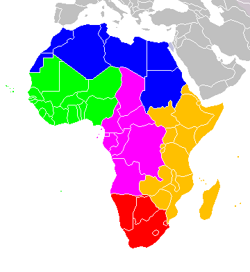
Africa-regions.png (360 × 392 pixels, file size: 8 KB, MIME type: image/png)
File history
Click on a date/time to view the file as it appeared at that time.
| Lusuku/Sikhatsi | Thumbnail | Dimensions | Umuntfu | Comment | |
|---|---|---|---|---|---|
| current | 02:02, 1 iNhlaba 2018 |  | 360 × 392 (8 KB) | Vesperius | Reverted to version as of 18:36, 28 May 2018 (UTC) (Most definitions of the regions include the Horn of Africa as part of East Africa, so I'm reverting this back) |
| 18:37, 28 iNkhwekhweti 2018 |  | 360 × 392 (10 KB) | Vesperius | Reverted to version as of 18:25, 28 May 2018 (UTC) (Messed up, the purple indicating the Horn of Africa didn't show up for me) | |
| 18:36, 28 iNkhwekhweti 2018 |  | 360 × 392 (8 KB) | Vesperius | Reverted to version as of 01:04, 16 May 2018 (UTC) | |
| 18:25, 28 iNkhwekhweti 2018 |  | 360 × 392 (10 KB) | Vesperius | Reverted to version as of 18:57, 17 March 2018 (UTC) | |
| 01:04, 16 iNkhwekhweti 2018 |  | 360 × 392 (8 KB) | Dwo | Reverted to version as of 08:22, 30 August 2015 (UTC) | |
| 18:57, 17 iNdlovu 2018 |  | 360 × 392 (10 KB) | Maphobbyist | Montenegro border | |
| 08:22, 30 iNgci 2015 |  | 360 × 392 (8 KB) | Wiki-Zyron | Reverted to version as of 00:23, 20 December 2012 - Reverted to the last version before someone inexplicably moved Zimbabwe to Southern Africa. Eastern Africa is the correct region - [http://unstats.un.org/unsd/methods/m49/m49regin.htm#africa] | |
| 05:04, 21 Mabasa 2015 |  | 360 × 392 (16 KB) | TAKASUGI Shinji | Corrected the color of Zimbabwe | |
| 15:16, 18 iNgongoni 2014 |  | 360 × 392 (17 KB) | Hybscher | wrong colors | |
| 22:39, 22 Lweti 2014 |  | 2,000 × 2,050 (342 KB) | Andrew J.Kurbiko | pp |
File usage
The following page uses this file:
Global file usage
The following other wikis use this file:
- Usage on af.wikipedia.org
- Usage on anp.wikipedia.org
- Usage on ar.wikipedia.org
- Usage on arz.wikipedia.org
- Usage on avk.wikipedia.org
- Usage on azb.wikipedia.org
- Usage on ba.wikipedia.org
- Usage on bg.wikipedia.org
- Usage on blk.wikipedia.org
- Usage on bn.wikipedia.org
- Usage on br.wikipedia.org
- Usage on bxr.wikipedia.org
- Usage on ca.wikipedia.org
- Usage on cy.wikipedia.org
- Usage on de.wikipedia.org
- Usage on el.wikipedia.org
- Usage on en.wikipedia.org
- Southern Africa
- Walvis Bay-Ndola-Lubumbashi Development Road
- N1 road (Gabon)
- User:R4000/Africa(Alt)
- Cairo Road
- User:ArminHammer
- User:Donbert/motherafrica
- User:Donbert/userboxes
- United Nations geoscheme
- United Nations geoscheme for Africa
- Rua Libertadores de África
- Lists of cities in Africa
- Portuguese Africans
- Sam Nujoma Street
- Cairo–Dakar Highway
- N'Djamena–Djibouti Highway
- Portal:Africa/Countries
View more global usage of this file.


